
Sayward September Showcase (20-22 Sept) is ready to go!
- Jonathan Binnington
- Sep 3, 2024
- 4 min read

Yes! It really is that stunning….. Hkusam Mountain, 1645m
Monday 2 September was the day that five of us went up to Sayward Junction to complete the preparations for the season finale event, the Sayward September Showcase (Fri evening 20 Sept to Sun afternoon 22 September). https://www.gr200.com/product-page/sayward-september-showcase-a-dualsport-navigation-duel
The roadbooks were completed a number of weeks ago, the route comprises roads that have by now become well-known and familiar to me and my riding colleagues who have made it our business to learn what we can about the northern half of Vancouver Island.
The task at hand was to proof read the roadbook for the second day and to set the gps timing marks for the time/speed/distance regularity rally competition.
Outline of how VIME time-speed-distance enduros work:
For those of you new here, the VIME events are grassroots backcountry motorcycle motorsport events, aimed at new and casual motorsport riders on road legal dualsport and adventure bikes. The routes are typically between 100km and 100mi in length and would otherwise constitute a “good day out”.
The test posed by these events are tests of navigation skills, not tests of speed, racing or technical riding skills. The degree of difficulty is nowhere near as difficult as trials, MX or hard-enduro. The routes hark back to the classical days of “enduro” where the emphasis is on distance and endurance with navigation skills thrown in. Routes are provided at three levels of difficulty.
The entry level is a Gaia route, download the route into your subscription-paid smartphone Gaia and follow the line…
The next level is to have the route by rally-style roadbook and follow the same route by way of tulip diagrams, distance measurements and compass headings.
The competition level is to navigate by roadbook and to keep to the set average speeds over GPS timed sections.
The softwares to complete are all smartphone apps,
Gaia is a mapping app, (free download, 70$ subscription required for out-of-cell-service use)
the roadbook is a PDF displayed on Rally Roadbook Reader that has its own GPS speedometer/odometer and clock (free download and use)
The timing is by Richta Rally Timing (free download and use)
All these are available from where you usually get your apps. Rally Roadbook Reader and Richta, being separate apps, might initially appear clunky when compared to integrated rally softwares that you might have heard about …. but are simple and straightforward in use and do not require you to learn the cryptic meanings of more than one hundred symbols in order to decipher the meaning of the roadbook.
The roadbooks will require you to understand the meanings of a few symbols, but these are the same symbols used on road signs, such a maximum speed limits (numbers in circles), STOP in a red circle, black and white checkered flag for finish. This isn’t any harder than it absolutely needs to be in order to convey the necessary information.

The directions are read line by line, junction by junction.
The large black numbers down the left hand side are the accumulating distance, the small black number in the black box is the distance to the next junction, the white number in the black box is the number of the junction on the route.
The diagram in the middle box is a sketch of the road junction layout.
The information in the right hand box give the compass heading out of the junction (CAP heading for reasons I have not been able to learn) with dialogue to further explain and the latitude and longitude of the junction.
Riders in the competition class ride singly, riders in the other two classes can buddy-up. Every start is a single start, no mass start hole-shots!
Report of the route-setting day and photos:
Labour Day Monday on the north of Vancouver Island turned out to be the first day of a fine and mellow autumn to come! The height of the summer heat had passed, the looming threat of wildfires had receded and we were left with a fine sunny day with cool winds and just a hint of browns and reds in the trees. Some of the roads were still summer-dusty, others remained damp from recent rainy days and were an absolute pleasure to ride on.


Victoria peak 2163m (rt)
Warden Peak 1970m (lt)
Given the route was known, it was tackled “con brio” although at all times being alert to the possibility of oncoming traffic. Very little traffic was actually encountered and no commercial traffic, probably a result of the public holiday and the imminent start of the new school year.
The route was completed, no errors in the roadbook to correct, the set average speeds seemed appropriate for an enjoyable day out without the need for any reckless riding and all the GPS timing pins were set correctly. So the event is now set and ready to go!
The first day is Saturday 21 September, the start and finish for both days is from the Sayward Junction CoOp petrol station. 227 off-road kilometres on Saturday, 110km on Sunday to enable a reasonably timed return ferry to Vancouver on Sunday evening (Nanaimo Departure Bay or Duke Point whichever has the best sailing times for you).
Accommodations at the Sayward Valley resort, cabins, RV or camping. Alas the accommodation is not included in the entry fee. Dinners and beer in the Crossroads Restaurant, also not included in the entry fee! Petrol from the Sayward Junction CoOp.
For the avoidance of all doubt, Sayward Junction is on Hwy 19, north of Campbell River,
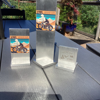
There are trophies to award, for the winner of the weekend event (timed rides) and the overall winner and second of the season awards.


All participants get an event tee shirt, further shirts available for purchase. I look forwards to seeing you at the event for a very satisfying end to our event season.
Regards
Jonathan Binnington. Proprietor Vancouver Island Motosports Events.
Comments